Stadt Dortmund: Berufskolleg
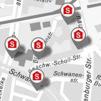
Karte mit den Standorten derBerufskollegs in Dortmund
Sachinformationen können über den Layer „Stadt Dortmund: Sachinformationen zu Berufliche Bildung“ aufgerufen werden.
Simple
- Date (Revision)
- 2017-09-20T08:01:36
- Status
- On going
- Keywords
-
-
infoMapAccessService
-
-
Anwendungen
-
-
map.apps
-
-
theme.govdata
-
-
Bildung und Wissenschaft
-
Bevölkerung
-
- Theme
-
-
Dortmund
-
Resource constraints
No information provided.
- Use limitation
-
Datenlizenz Deutschland – Namensnennung – Version 2.0
- Use constraints
- License
- Topic category
-
- Society
N
S
E
W
))
- Reference system identifier
- CRS:84
- Reference system identifier
- EPSG:25832
- Reference system identifier
- EPSG:3857
- Reference system identifier
- EPSG:31467
- Reference system identifier
- EPSG:31466
- Reference system identifier
- EPSG:4326
- Distribution format
-
-
WMS
(
1.3.0
)
-
WMS
(
1.3.0
)
- OnLine resource
- Berufskolleg ( OGC:WMS-1.3.0-http-get-map )
- OnLine resource
- default (LegendURL) ( image/png )
- Hierarchy level
- Dataset
- Statement
-
Eigene Erfassung
- File identifier
- 7abffd1f578f80f7ce9c381db262124df28ff9c7 XML
- Metadata language
-
ger
- Character set
- UTF8
- Hierarchy level
- Dataset
- Date stamp
- 2017-09-20T08:54:03
- Metadata standard name
-
ISO 19115:2003/19139
- Metadata standard version
-
1.0
Overviews
thumbnail
Spatial extent
N
S
E
W
Provided by
Associated resources
Not available