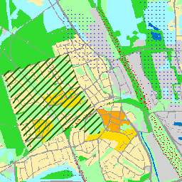
Planungshinweiskarten - Schraffuren
Raumspezifische Hinweise werden durch flächenhafte Schraffuren gekennzeichnet.
Simple
- Date (Creation)
- 2020-08-01
- Date (Revision)
- 2020-11-10
- Identifier
- https://registry.gdi-de.org/id/de.nw/0e2ac37e-3891-4956-beab-420967f9036d
- Theme
-
-
Planungshinweise
-
Planungshinweiskarte
-
Planungsempfehlungen
-
Stadtplanung
-
Lastraum
-
Ausgleichsraum
-
Stadtklima
-
Umwelt
-
Klima
-
opendata
-
- Access constraints
- Other restrictions
- Use limitation
-
Nutzungsbedingungen: Creative Commons Namensnennung, nicht kommerziell 4.0 International
- Use constraints
- Other restrictions
- Other constraints
-
Nutzungsbedingungen: Creative Commons Namensnennung, nicht kommerziell 4.0 International
- Other constraints
-
{"id":"cc-by-nc/4.0", "name": "Creative Commons Namensnennung, nicht kommerziell 4.0 International", "url": " https://creativecommons.org/licenses/by-nc/4.0/ ", "quelle": "Quelle: © Regionalverband Ruhr"}
- Metadata language
-
ger
- Topic category
-
- Climatology, meteorology, atmosphere
))
- Unique resource identifier
- EPSG:25832
- OnLine resource
-
Schraffuren
(
OGC:WMS
)
Planungshinweiskarten - Schraffuren
- OnLine resource
- Planungshinweiskarten - Schraffuren ( WWW:LINK-1.0-http--link )
- Hierarchy level
- Dataset
- Statement
-
Bearbeitung des Teams 20-2 unter anderem auf Grundlage der Flächennutzung
- File identifier
- 09363718-fde7-49e5-b5a5-83a6595b1232 XML
- Metadata language
- Deutsch
- Character set
- UTF8
- Hierarchy level
- Dataset
- Date stamp
- 2022-05-09
- Metadata standard name
-
ISO 19115:2003/19139
- Metadata standard version
-
1.0
Overviews
Spatial extent
Provided by
