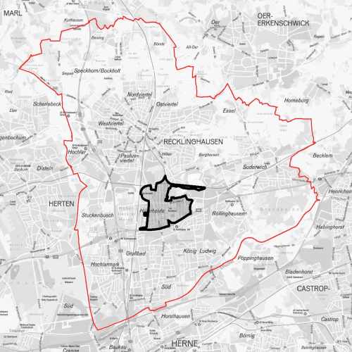
Stadtumbaugebiet Hillerheide
Übersicht der Bereichsgrenzen des Stadtumbaugebietes Hillerheide.
Der Raumbezug wird durch FB 62.12 (Geoinformationssysteme) hergestellt.
Simple
- Date (Creation)
- 2017-09-11
- Identifier
- https://registry.gdi-de.org/id/de.nw/ee0a3320-ca0d-4195-9a2b-749c9c03383c
- Status
- Completed
- Theme
-
-
Entwicklungsgebiet
-
Stadtgebiet
-
opendata
-
SOCI
-
- Access constraints
- Other restrictions
- Other constraints
- Es gelten keine Zugriffsbeschränkungen
- Use limitation
-
Nutzungsbedingungen: Datenlizenz Deutschland Namensnennung 2.0
- Use constraints
- Other restrictions
- Other constraints
-
Nutzungsbedingungen: Datenlizenz Deutschland Namensnennung 2.0
- Other constraints
-
{"id": "dl-by-de/2.0", "name": "Datenlizenz Deutschland Namensnennung 2.0", "url": " http://www.govdata.de/dl-de/by-2-0 ", "quelle": "Quelle: © Stadt Recklinghausen"}
- Spatial representation type
- Vector
- Metadata language
- Deutsch
- Topic category
-
- Planning cadastre
N
S
E
W
))
- Unique resource identifier
- EPSG:25832
- Distribution format
-
-
MapInfo
(
)
-
MapInfo
(
)
- Name
-
Stadtumbaugebiet Hillerheide
- Description
-
Stadtumbaugebiet Hillerheide
- Function
- Download
- File identifier
- 22ac1a20-605a-4b36-98be-640a7bbd9297 XML
- Metadata language
- Deutsch
- Character set
- UTF8
- Hierarchy level
- Dataset
- Date stamp
- 2024-11-13
- Metadata standard name
-
ISO 19115:2003/19139
- Metadata standard version
-
1.0
Overviews
thumbnail
Spatial extent
N
S
E
W
Provided by

Associated resources
Not available