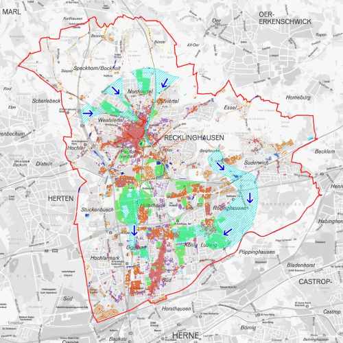
Klimaanpassungskarte
Bereiche im Stadtgebiet, die heute oder in Zukunft hitze- oder überflutungsgefährdet sind.
Der Raumbezug wird durch FB 62.12 (Geoinformationssysteme) hergestellt.
Simple
- Date (Creation)
- 2018-11-07
- Date (Revision)
- 2019-05-13
- Identifier
- https://registry.gdi-de.org/id/de.nw/b7a1764e-8f2e-4f2e-afc8-2727cb02d036
- Status
- On going
- Theme
-
-
Wärme
-
Klimaschutz
-
Klima
-
opendata
-
ENVI
-
- Access constraints
- Other restrictions
- Other constraints
- Es gelten keine Zugriffsbeschränkungen
- Use limitation
-
Nutzungsbedingungen: Datenlizenz Deutschland Namensnennung 2.0
- Use constraints
- Other restrictions
- Other constraints
-
Nutzungsbedingungen: Datenlizenz Deutschland Namensnennung 2.0
- Other constraints
-
{"id": "dl-by-de/2.0", "name": "Datenlizenz Deutschland Namensnennung 2.0", "url": " http://www.govdata.de/dl-de/by-2-0 ", "quelle": "Quelle: © Stadt Recklinghausen"}
- Spatial representation type
- Vector
- Metadata language
- Deutsch
- Topic category
-
- Environment
N
S
E
W
))
- Unique resource identifier
- EPSG:25832
- Distribution format
-
-
MapInfo
(
)
-
MapInfo
(
)
- Name
-
Klimaanpassungskarte
- Description
-
Klimaanpassungskarte
- Function
- Download
- File identifier
- 3177fbde-2a0d-41b0-a71c-567d20324781 XML
- Metadata language
- Deutsch
- Character set
- UTF8
- Hierarchy level
- Dataset
- Date stamp
- 2025-04-15
- Metadata standard name
-
ISO 19115:2003/19139
- Metadata standard version
-
1.0
Overviews
thumbnail
Spatial extent
N
S
E
W
Provided by

Associated resources
Not available