Stadt Dortmund: WMS - Luftbilder 2016 beschriftet
Dienst mit den Orthofotos der Stadt Dortmund erweitert um eine Beschriftung der Straßennamen
Simple
Identification info
- Date (Revision)
- 2016-01-01T12:00:00
- Identifier
- https://geoweb1.digistadtdo.de/geodatenkatalog/srv/resources32781c16-c7d1-41e5-97ac-24ef062ec2b4
- Status
- On going
Point of contact
Stadt Dortmund
-
Geoinformation Stadt Dortmund
(
)
http://geonetwork-opensource.org/
-
Anwendungen
-
-
map.apps
-
- Theme
-
-
WMS
-
OSGeo
-
-
theme.govdata
-
-
Geographie, Geologie und Geobasisdaten
-
- Service Type
- OGC:WMS
- Service Version
-
1.3.0
- Fees
-
NONE
- Use limitation
-
Datenlizenz Deutschland – Namensnennung – Version 2.0
- Use constraints
- License
N
S
E
W
))
- Coupling Type
- Tight
Contains Operations
- Operation Name
-
GetCapabilities
- Connect Point
- Format : application/vnd.ogc.wms_xml ( WWW:LINK-1.0-http--link )
Contains Operations
- Operation Name
-
GetMap
- Distributed Computing Platforms
- Web services
- Connect Point
- Format : image/png ( WWW:LINK-1.0-http--link )
- Connect Point
- Format : application/atom+xml ( WWW:LINK-1.0-http--link )
- Connect Point
- Format : application/openlayers ( WWW:LINK-1.0-http--link )
- Connect Point
- Format : application/pdf ( WWW:LINK-1.0-http--link )
- Connect Point
- Format : application/rss+xml ( WWW:LINK-1.0-http--link )
- Connect Point
- Format : application/vnd.google-earth.kml+xml ( WWW:LINK-1.0-http--link )
- Connect Point
- Format : application/vnd.google-earth.kmz ( WWW:LINK-1.0-http--link )
- Connect Point
- Format : image/geotiff ( WWW:LINK-1.0-http--link )
- Connect Point
- Format : image/geotiff8 ( WWW:LINK-1.0-http--link )
- Connect Point
- Format : image/gif ( WWW:LINK-1.0-http--link )
- Connect Point
- Format : image/jpeg ( WWW:LINK-1.0-http--link )
- Connect Point
- Format : image/png8 ( WWW:LINK-1.0-http--link )
- Connect Point
- Format : image/svg+xml ( WWW:LINK-1.0-http--link )
- Connect Point
- Format : image/tiff ( WWW:LINK-1.0-http--link )
- Connect Point
- Format : image/tiff8 ( WWW:LINK-1.0-http--link )
Contains Operations
- Operation Name
-
GetFeatureInfo
- Connect Point
- Format : text/plain ( WWW:LINK-1.0-http--link )
- Connect Point
- Format : text/html ( WWW:LINK-1.0-http--link )
- Connect Point
- Format : application/vnd.ogc.gml ( WWW:LINK-1.0-http--link )
Contains Operations
- Operation Name
-
DescribeLayer
- Connect Point
- Format : application/vnd.ogc.wms_xml ( WWW:LINK-1.0-http--link )
Contains Operations
- Operation Name
-
GetLegendGraphic
- Connect Point
- Format : image/png ( WWW:LINK-1.0-http--link )
- Connect Point
- Format : image/jpeg ( WWW:LINK-1.0-http--link )
- Connect Point
- Format : image/gif ( WWW:LINK-1.0-http--link )
- Distribution format
-
-
(
)
-
(
)
- OnLine resource
-
RVR_ATLAS
(
OGC:WMS-1.3.0-http-get-map
)
RVR_LUFTBILDER
- OnLine resource
- thumbnail ( WWW:LINK-1.0-http--link )
- File identifier
- 32781c16-c7d1-41e5-97ac-24ef062ec2b4 XML
- Metadata language
- Deutsch
- Character set
- UTF8
- Hierarchy level
- Service
- Hierarchy level name
-
WMS-Dienst
- Date stamp
- 2017-09-07T13:22:18
- Metadata standard name
-
ISO 19115:2003/19139
- Metadata standard version
-
1.0
Point of contact
Stadt Dortmund
-
Geoinformation
(
Geodatenmanager
)
Telephone number of a facsimile machine for the responsible organization or individual
http://geo.dortmund.de
Märkische Straße 24-26
,
Dortmund
,
NRW
,
44122
,
Germany
+492315022393
Telephone number of a facsimile machine for the responsible organization or individual
http://geo.dortmund.de
Overviews
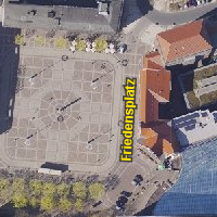
thumbnail
Spatial extent
N
S
E
W
Provided by
Associated resources
Not available