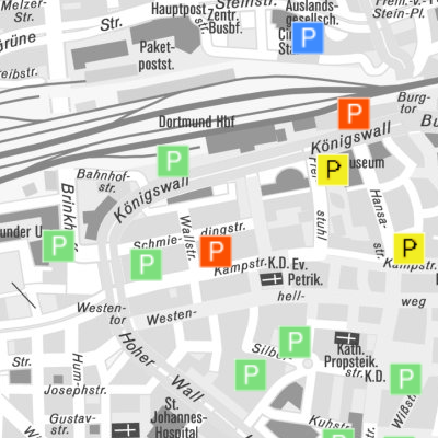
Stadt Dortmund: WMS - Parkhäuser
Informationen über die Standorte und die Belegung der Parkhäuser in Dortmund
Simple
Identification info
- Date (Revision)
- 2017-08-24
- Identifier
- https://geoweb1.digistadtdo.de/geodatenkatalog/srv/resources6963d1f9ecddcb116ff2789b8a6014db33df017b
- Status
- On going
Telephone number of a facsimile machine for the responsible organization or individual
https://geoweb1.digistadtdo.de/doris_gdi/
-
ISO
-
-
infoMapAccessService
-
-
Anwendungen
-
-
map.apps
-
- Access constraints
- Other restrictions
- Other constraints
-
Stadt Dortmund
- Service Type
- OGC:WMS
- Service Version
-
1.3.0
- Fees
-
conditions unknown
))
Coupled Resource
- Operation Name
-
GetCapabilities
- Identifier
-
e54fa820-cfcf-4b5f-ac2e-767440179551
- Coupling Type
- Tight
Contains Operations
- Operation Name
-
GetCapabilities
- Distributed Computing Platforms
- HTTP-GET
- Connect Point
-
Format : text/xml
(
text/xml
)
Format :
text/xml
Contains Operations
- Operation Name
-
GetMap
- Distributed Computing Platforms
- HTTP-GET
- Connect Point
-
Format : image/jpeg
(
image/jpeg
)
Format :
image/jpeg
- Connect Point
-
Format : image/png
(
image/png
)
Format :
image/png
- Connect Point
-
Format : image/png; mode=16bit
(
image/png; mode=16bit
)
Format :
image/png; mode=16bit
- Connect Point
-
Format : image/png; mode=8bit
(
image/png; mode=8bit
)
Format :
image/png; mode=8bit
- Connect Point
-
Format : image/png; mode=1bit
(
image/png; mode=1bit
)
Format :
image/png; mode=1bit
- Connect Point
-
Format : application/dxf
(
application/dxf
)
Format :
application/dxf
Contains Operations
- Operation Name
-
GetFeatureInfo
- Distributed Computing Platforms
- HTTP-GET
- Connect Point
-
Format : text/plain
(
text/plain
)
Format :
text/plain
- Connect Point
-
Format : text/html
(
text/html
)
Format :
text/html
- Connect Point
-
Format : text/xml
(
text/xml
)
Format :
text/xml
- Connect Point
-
Format : application/vnd.ogc.gml
(
application/vnd.ogc.gml
)
Format :
application/vnd.ogc.gml
- Connect Point
-
Format : application/vnd.ogc.gml/3.1.1
(
application/vnd.ogc.gml/3.1.1
)
Format :
application/vnd.ogc.gml/3.1.1
Contains Operations
- Operation Name
-
sld:GetLegendGraphic
- Distributed Computing Platforms
- HTTP-GET
- Connect Point
-
Format : image/jpeg
(
image/jpeg
)
Format :
image/jpeg
- Connect Point
-
Format : image/png
(
image/png
)
Format :
image/png
Contains Operations
- Operation Name
-
sld:DescribeLayer
- Distributed Computing Platforms
- HTTP-GET
- Connect Point
-
Format : text/xml
(
text/xml
)
Format :
text/xml
Contains Operations
- Operation Name
-
qgs:GetStyles
- Distributed Computing Platforms
- HTTP-GET
- Connect Point
-
Format : text/xml
(
text/xml
)
Format :
text/xml
- Operates On
- Reference system identifier
- EPSG / DHDN / 3-degree Gauss-Kruger zone 2 (EPSG:31466) / 8.6
- Reference system identifier
- EPSG / DHDN / 3-degree Gauss-Kruger zone 3 (EPSG:31467) / 8.6
- Reference system identifier
- EPSG / ETRS89 / UTM zone 32N (EPSG:25832) / 8.6
- Distribution format
-
-
WMS
(
1.3.0
)
-
WMS
(
1.3.0
)
- OnLine resource
-
DORIS_Parken
(
OGC:WMS-1.1.1-http-get-map
)
Parken in Dortmund
- OnLine resource
- thumbnail ( WWW:LINK-1.0-http--link )
- Hierarchy level
- Service
Attributes
- File identifier
- 3917f14c-1d87-4f5a-a235-e40a698b1d56 XML
- Metadata language
- Deutsch
- Character set
- UTF8
- Hierarchy level
- Service
- Hierarchy level name
-
WMS-Dienst
- Date stamp
- 2017-09-01T09:17:42
- Metadata standard name
-
ISO 19119/2005
- Metadata standard version
-
1.0
Telephone number of a facsimile machine for the responsible organization or individual
https://geoweb1.digistadtdo.de/doris_gdi/
Overviews
Spatial extent
Provided by