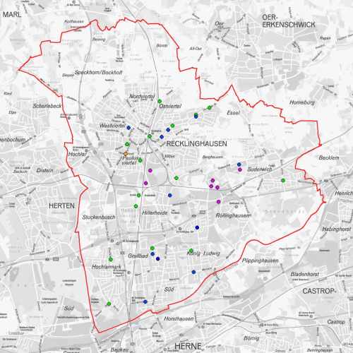
Kreisverkehre
Lage von Kreisverkehren mit Angabe von Art und Ausgestaltung im Stadtgebiet Recklinghausen.
Der Raumbezug wird durch FB 62.12 (Geoinformationssysteme) hergestellt.
Simple
- Date (Creation)
- 2020-03-02
- Date (Revision)
- 2023-03-13
- Identifier
- https://registry.gdi-de.org/id/de.nw/80998e71-29ab-4c2f-814a-5b0b9503736d
- Status
- On going
- Theme
-
-
Verkehrslenkung
-
Verfahrenstechnik
-
Stadtverkehr
-
opendata
-
TRAN
-
- Access constraints
- Other restrictions
- Other constraints
- Es gelten keine Zugriffsbeschränkungen
- Use limitation
-
Nutzungsbedingungen: Datenlizenz Deutschland Namensnennung 2.0
- Use constraints
- Other restrictions
- Other constraints
-
Nutzungsbedingungen: Datenlizenz Deutschland Namensnennung 2.0
- Other constraints
-
{"id": "dl-by-de/2.0", "name": "Datenlizenz Deutschland Namensnennung 2.0", "url": " http://www.govdata.de/dl-de/by-2-0 ", "quelle": "Quelle: © Stadt Recklinghausen"}
- Spatial representation type
- Vector
- Metadata language
- Deutsch
- Topic category
-
- Transportation
))
- Unique resource identifier
- EPSG:25832
- Distribution format
-
-
MapInfo
(
)
-
MapInfo
(
)
- Name
-
Kreisverkehre
- Description
-
Kreisverkehre
- Function
- Download
- File identifier
- 42f21013-9cee-4776-b8e5-41cc6dcce7a3 XML
- Metadata language
- Deutsch
- Character set
- UTF8
- Hierarchy level
- Dataset
- Date stamp
- 2024-11-13
- Metadata standard name
-
ISO 19115:2003/19139
- Metadata standard version
-
1.0
Overviews
Spatial extent
Provided by