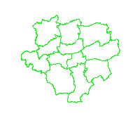
Stadtbezirke
Graphische Darstellung der 12 Stadtbezirke
Simple
- Date (Revision)
- 2018-11-09
- Status
- Completed
- Theme
-
-
infoMapAccessService
-
-
Anwendungen
-
-
map.apps
-
-
theme.govdata
-
-
Bevölkerung
-
Geographie, Geologie und Geobasisdaten
-
- Use limitation
-
Datenlizens Deutschland - Namensnennung - Version 2.0
- Use constraints
- License
- Metadata language
-
ger
- Character set
- UTF8
- Topic category
-
- Boundaries
N
S
E
W
))
- Reference system identifier
- CRS:84
- Reference system identifier
- EPSG:25832
- Reference system identifier
- EPSG:4258
- Reference system identifier
- EPSG:4326
- Reference system identifier
- EPSG:4839
- Reference system identifier
- EPSG:25833
- Reference system identifier
- EPSG:31466
- Reference system identifier
- EPSG:31467
- Reference system identifier
- EPSG:31468
- Reference system identifier
- EPSG:31469
- Reference system identifier
- EPSG:3044
- Reference system identifier
- EPSG:3045
- Distribution format
-
-
WMS
(
1.3.0
)
-
WMS
(
1.3.0
)
- OnLine resource
- Stadtbezirke ( OGC:WMS-1.3.0-http-get-map )
- OnLine resource
- default (LegendURL) ( image/png )
- Hierarchy level
- Dataset
- Statement
-
Eigene Erfassung
- File identifier
- 90c4a6f6e3b96d9f96e613d5dd52162675d2fa7f XML
- Metadata language
-
ger
- Character set
- UTF8
- Hierarchy level
- Dataset
- Date stamp
- 2018-11-09T10:12:25
- Metadata standard name
-
ISO 19115:2003/19139
- Metadata standard version
-
1.0
Overviews
thumbnail
Spatial extent
N
S
E
W
Provided by

Associated resources
Not available