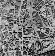
Digitalisierte Luftbilder RVR 1969 - LUBI 1969
Die Luftbilder stammen aus den Jahren 1957 bis 1980 und sind mit einer Bodenauflösung von 0,3175m beflogen. Die Aufnahmen liegen in schwarz-weiß vor.
Simple
- Date (Creation)
- 2015-08-12
- Date (Revision)
- 2019-11-21
- Identifier
- https://registry.gdi-de.org/id/de.nw/52890181-ed29-4951-bc8c-b10c184275a8
- Theme
-
-
Luftbilder
-
1969
-
Geobasisdaten
-
Regionalverband Ruhr
-
RVR
-
NRW
-
Nordrhein-Westfalen
-
Ruhrgebiet
-
Planung
-
Umwelt
-
Verkehr
-
Freiraumentwicklung
-
Wirtschaft
-
Luftbildinterpretation
-
Dokumentation
-
opendata
-
- Access constraints
- Other restrictions
- Use limitation
-
Nutzungsbedingungen: Datenlizenz Deutschland Namensnennung 2.0
- Use constraints
- Other restrictions
- Other constraints
-
Nutzungsbedingungen: Datenlizenz Deutschland Namensnennung 2.0
- Other constraints
-
{"id":"dl-by-de/2.0", "name": "Datenlizenz Deutschland Namensnennung 2.0", "url": " http://www.govdata.de/dl-de/by-2-0 ", "quelle": "Quelle: © Regionalverband Ruhr"}
- Metadata language
-
ger
- Topic category
-
- Imagery base maps earth cover
))
- Unique resource identifier
- EPSG:25832
- OnLine resource
-
lubi_1969
(
OGC:WMS
)
Digitalisierte Luftbilder RVR 1969 - LUBI 1969
- OnLine resource
- Digitalisierte Luftbilder RVR 1969 - LUBI 1969 ( WWW:LINK-1.0-http--link )
- Hierarchy level
- Dataset
- Statement
-
Luftbildbefliegung des Siedlungsverband Ruhrkohlenbezirk: Befliegung durch Plan und Karte GmbH Münster, Hansa Luftbild GmbH, Aero Exploration, Aerowest Photogrammetrie Hengstbach KG, Aerowest Photogrammetrie H. Benfer KG
- File identifier
- a0331105-f2c3-4727-8dfa-a386512ed91a XML
- Metadata language
- Deutsch
- Character set
- UTF8
- Hierarchy level
- Dataset
- Date stamp
- 2025-11-18
- Metadata standard name
-
ISO 19115:2003/19139
- Metadata standard version
-
1.0
Overviews
Spatial extent
Provided by
